You have 45 seconds. Name the 3 left-bank tributaries of the Brahmaputra. Can't? Neither can most aspirants. Let's fix that right now.
The river system of Assam is an absolute nightmare for exam prep. Every year, examiners use these rivers to confuse students. Today, we are breaking down the Brahmaputra tributaries with a visual trick that will make forgetting them impossible.
Before your exam, you need to map these exact rivers in your head, because exam setters love to ask about them.
⚡ At a Glance — Brahmaputra Tributaries
- Originates in Tibet as Yarlung Tsangpo.
- Enters Assam after Dibang and Lohit join the Siang river.
- Right Bank rivers come from the Northern Himalayas.
- Left Bank rivers come from the Southern hills.
- 🎯 Exam Tip: North bank rivers are highly braided and flood-prone.
- ⚠️ Common Trap: Mixing up Dhansiri (Left) and Subansiri (Right).
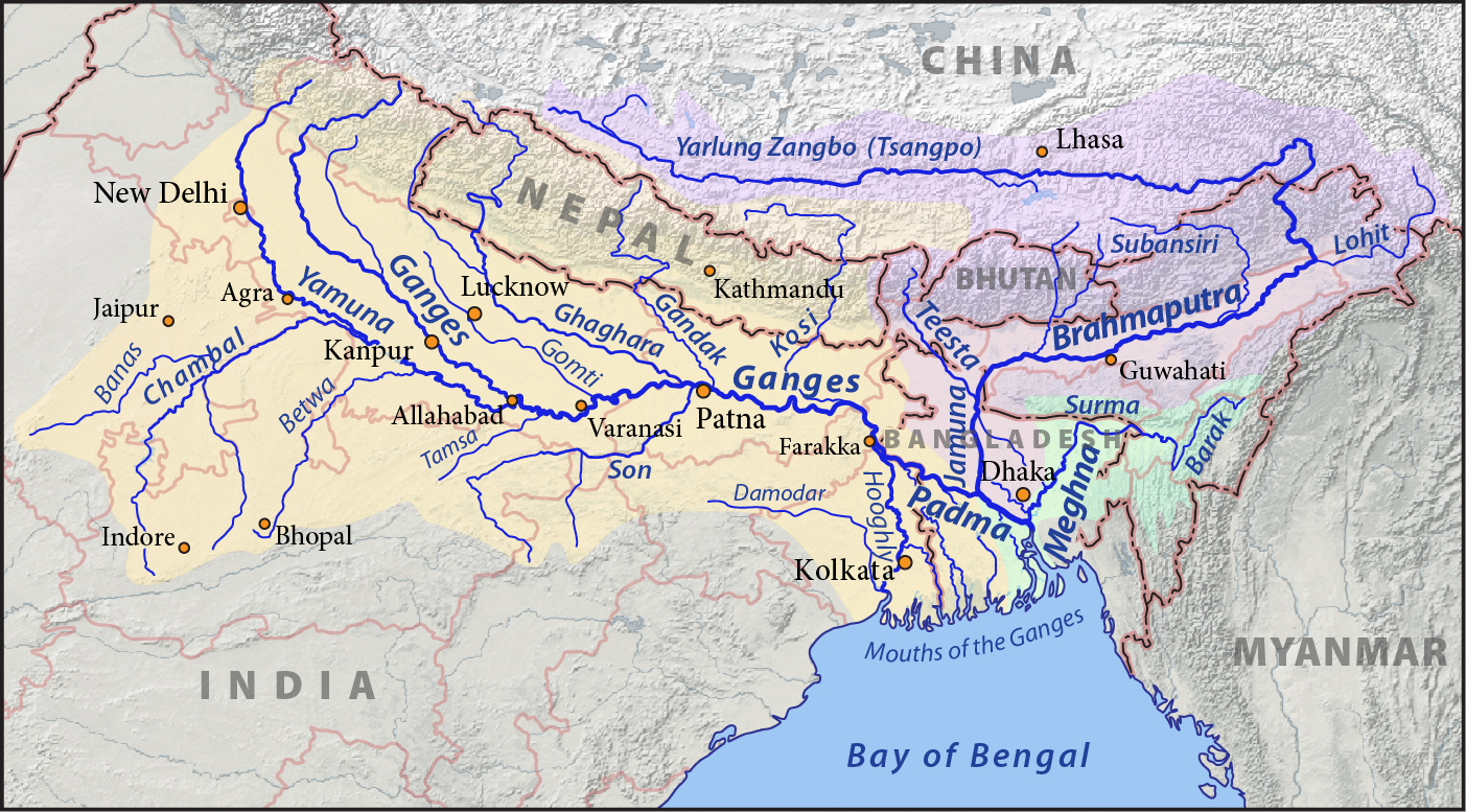
🗺️ The Right Bank (North) — Brahmaputra Tributaries
The right-bank tributaries of the Brahmaputra originate in the steep Northern Himalayas of Arunachal Pradesh and Bhutan. They carry heavy silt, flow rapidly, and have highly braided channels. Key rivers include Subansiri, Kameng, Manas, Beki, Sankosh, and Teesta.
Because of their steep gradient from the mountains to the plains, these rivers are largely responsible for sudden, flashy floods in lower Assam. The Kameng river is locally known as Jia Bharali in Sonitpur and flows near the Nameri National Park.
🟢 3 seconds trick: To remember Right Bank rivers, use the phrase: "Suba Kams to Make Some Tea" (Subansiri, Kameng, Manas, Sankosh, Teesta).
🗺️ The Left Bank (South) — The Gentle Meanders
The left-bank tributaries flow from the Southern and Eastern hill ranges, including the Naga hills, Meghalaya plateau, and Patkai Bum. They generally have a flatter gradient and deep, meandering channels.
Major left-bank rivers include Dibang, Lohit, Burhi Dihing, Dhansiri, Kolong, and Kopili. The Burhi Dihing winds through the lush Dehing Patkai landscape, while the Lohit forms the "foot" of the Brahmaputra near Sadiya.
📌 Exam Booster Fact: Kopili is the most prominent south-bank tributary in central Assam, heavily utilized for hydroelectric power generation in the Karbi Anglong district.
🗺️ The Ultimate Trap Rivers
Examiners love testing rivers that sound similar to confuse candidates. The most classic pair is Subansiri and Dhansiri.
The Subansiri is the largest tributary of the Brahmaputra, historically famous for gold dust, and it flows from the North (Right bank). In contrast, the Dhansiri originates in Nagaland's Laisang Peak, meanders near the Kaziranga National Park, and flows from the South (Left bank).
⚠️ Common trap in real papers: ADRE always tests the exact bank of these 'siri' rivers to see if you mapped them correctly in your head under pressure.
🗺️ The Border Rivers & Islands
The tributaries do more than add water; they shape the geography of Assam. The river splits into the northern Kherkutia channel (joined by the Subansiri) and the southern main channel, which later reunite to form Majuli, the world's largest river island.
Some rivers also define strict borders. The Manas River acts as a natural boundary between Assam and Bhutan, while the Sankosh River forms the westernmost border between Assam and West Bengal.
🔁 Real paper pattern: Exam setters love to ask which tributary creates the Majuli island bifurcation or acts as a natural state boundary.
🎯 Practice MCQs — Test Your Readiness
Q1. Which of the following statements regarding the Brahmaputra tributaries is/are correct?
1. The Subansiri is a left-bank tributary originating in Tibet.
2. The Manas River is a right-bank tributary that flows through Bhutan and Assam.
3. The Kopili River is a south-bank tributary originating in Meghalaya.
(A) 1 and 2 only
(B) 2 and 3 only
(C) 1 and 3 only
(D) 1, 2, and 3
✅ Answer: (B) 2 and 3 only — Subansiri is a right-bank (North) tributary, not a left-bank one.
Q2. A common trap in real papers involves rivers with similar names. Which of the following correctly pairs the river with its bank?
(A) Dhansiri - Right Bank
(B) Kameng - Left Bank
(C) Subansiri - Right Bank
(D) Burhi Dihing - Right Bank
✅ Answer: (C) Subansiri - Right Bank — Dhansiri and Burhi Dihing are Left (South), Kameng is Right (North).
Q3. Which north-bank tributary of the Brahmaputra acts as a natural boundary between Assam and West Bengal?
(A) Sankosh
(B) Raidak
(C) Beki
(D) Teesta
✅ Answer: (A) Sankosh — This river flows into Assam and forms the westernmost border with West Bengal.
Q4. The world's largest river island, Majuli, is formed by the Brahmaputra bifurcating into two channels. Which tributary joins the northern Kherkutia channel?
(A) Dhansiri
(B) Subansiri
(C) Kopili
(D) Beki
✅ Answer: (B) Subansiri — The river splits into the Kherkutia channel (north) and main Brahmaputra (south), with Subansiri joining the northern branch.
📋 10-Point Cheat Sheet — Revise in 2 Minutes
- 🟢 Subansiri — Right — Largest tributary of Brahmaputra
- 🟢 Kameng — Right — Also called Jia Bharali
- 🟢 Manas — Right — UNESCO border with Bhutan
- 🟢 Sankosh — Right — Border of Assam and Bengal
- 🟢 Teesta — Right — Joins in Bangladesh
- 🟢 Lohit — Left — Joins at Sadiya
- 🟢 Burhi Dihing — Left — Patkai hills origin
- 🟢 Dhansiri — Left — Originates in Nagaland
- 🟢 Kopili — Left — Hydropower in Karbi Anglong
- 🟢 Kolong — Left — Distributary turned tributary
IshaAI Pro Tip: Always draw a rough horizontal line representing the Brahmaputra and place arrows pointing from top and bottom to visualize tributaries before your exam.